


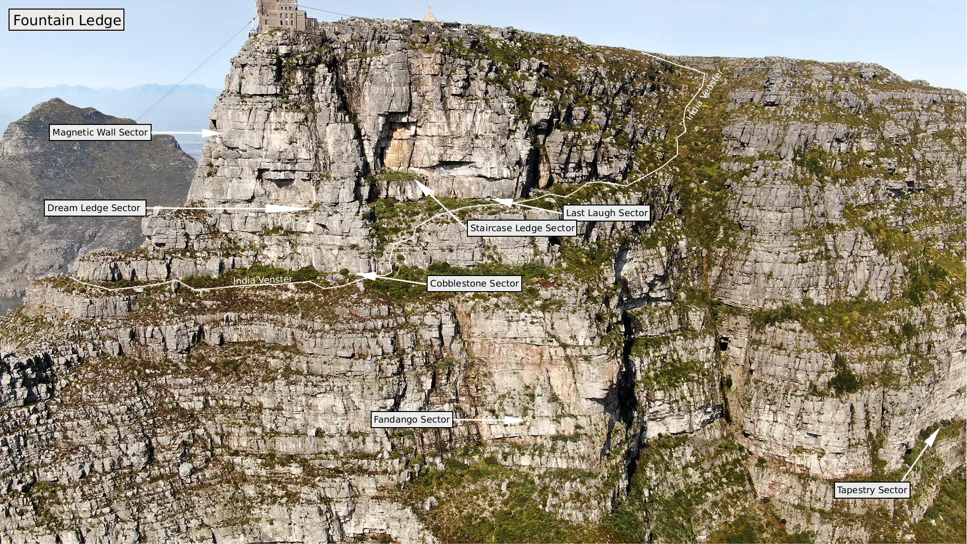
Fountain Ledge is the Western Face of the Top Band (top 150m) of rock of the main table, looking out over Camps Bay. More prone to seepage after rain than the Northern aspect crags (Africa Ledge & Lower Buttresses), Fountain Ledge is more protected from the South Easter wind during summer
Fountain Ledge offers, arguably, a higher concentration of routes in the easy-moderate and hard ranges (whereas Africa Ledge, arguably, has more medium-hard routes) - and home to the only route which will never go free!
Summer:
Best climbed in the mornings
Winter:
Best climbed in the afternoon sun
Local Advertisers
Approach
Approach
There are basically two ways to approach The Ledge.
- Take the cable car up and then Rappel down to the Ledge from various approved (with SANPARKS) bolted abseil points
- Walk Up.
The walk is great. It gives you a good warm-up, lets you enjoy the full mountain experience and gets you fit. The cablecar is quick and gets you to the top fresh. You can arrive on The Ledge with not even a bead of sweat on your brow. A return ticket is pricey once-off, for regular use a Green Card (issued by the Parks Board not US emigrations), gets you a substantial reduction on this price.
The path starts just before the bus parking at the lower cableway station. (100m before you get to the station when approaching it on Tafelberg Road). It takes a fairly direct line up to the contour path (This traverses aimost around the whole mountain at this level.) Cross the Contour Path and immediately start heading diagonally right.
As you head diagonally right a series of rock steps lead up to a flat platform on the top of the buttress, visible from below. The path now takes you up a gully. The Venster (rock window) can be seen on the left a short way up the gully. At the top of the gully the path suddenly flattens out for a short section allowing a great view of the second half of the route. The grassy bowl above is the top of India Ravine. The path traverses all the way along this to the top left-hand end where one follows a series of rock steps to finally top out via a gully to a spectacular view of Africa Ledge. (There are many options one can take on the rock scrambles. Take care.) At this point the cairned path moves slightly right, then swings left below the final rock band under Africa Ledge. You are now at the junction of Africa and Fountain Ledges (directly below Arrow Final).
To reach routes on Fountain Ledge walk right around the corner underneath the Magnetic Wall area, R<!St the Cobblestones Gendarme. Just past this the path swings sharply left and climbs a 15m rock step. (Do not carry on on the same level!)
somin- 1h30.
Descent
Descend either by walking around via the India Venter Path or by abseiling.
Each sector has unique Abseil Points, read the Sector Descent Beta for better info.
Walking:
From the top cableway station take any of the many paths heading east away from the sta tion towards Platteklip Gorge (signs). The Front Table is separated from the rest of the mountain by a small valley. Platteklip Gorge is on the left and Fountain Ravine on the right. From the bottom of the valley go sharp right heading for Fountain Ravine. Follow a slightly bushy path for a while past a small concrete pump house. Continue along the path, keep ing right, against the side of the valley passing a metal sign 'This is not an easy way down'. Do not drop down into Fountain Ravinell
The path is narrow as it traverses below ever steepening rock walls. Finally you will pass a deep chimney with a pipe running down it and pop around the corner onto Upper Fountain Ledge at its far right-hand end. Continue along beneath the Staircase Area and descend some small rock steps to a lower level. This carries on, passing the Cobblestone's Gendarme and the Magnetic Wall Area eventually turning another corner to reach the start of Africa Ledge. (20 - 30 min)
Magnetic Wall Sector
Lorem ipsum dolor sit amet, consectetur adipiscing elit. Suspendisse varius enim in eros elementum tristique. Duis cursus, mi quis viverra ornare, eros dolor interdum nulla, ut commodo diam libero vitae erat. Aenean faucibus nibh et justo cursus id rutrum lorem imperdiet. Nunc ut sem vitae risus tristique posuere.


The Dream Ledge
Lorem ipsum dolor sit amet, consectetur adipiscing elit. Suspendisse varius enim in eros elementum tristique. Duis cursus, mi quis viverra ornare, eros dolor interdum nulla, ut commodo diam libero vitae erat. Aenean faucibus nibh et justo cursus id rutrum lorem imperdiet. Nunc ut sem vitae risus tristique posuere.


Cobblestone Gendarme
Lorem ipsum dolor sit amet, consectetur adipiscing elit. Suspendisse varius enim in eros elementum tristique. Duis cursus, mi quis viverra ornare, eros dolor interdum nulla, ut commodo diam libero vitae erat. Aenean faucibus nibh et justo cursus id rutrum lorem imperdiet. Nunc ut sem vitae risus tristique posuere.


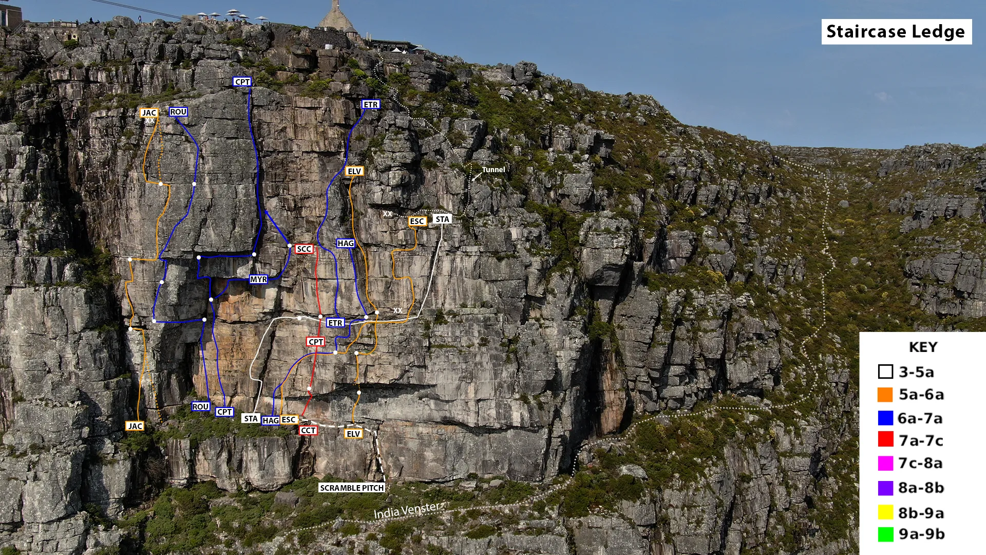
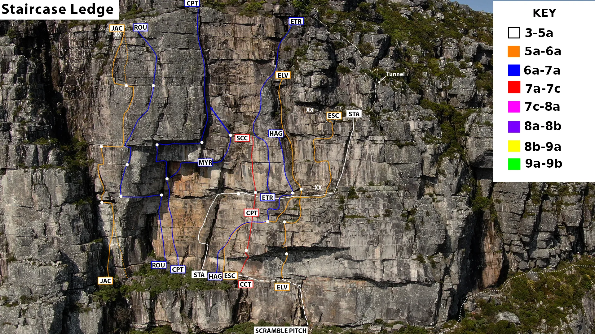
Staircase Ledge
Lorem ipsum dolor sit amet, consectetur adipiscing elit. Suspendisse varius enim in eros elementum tristique. Duis cursus, mi quis viverra ornare, eros dolor interdum nulla, ut commodo diam libero vitae erat. Aenean faucibus nibh et justo cursus id rutrum lorem imperdiet. Nunc ut sem vitae risus tristique posuere.


Last Laugh Sector
Lorem ipsum dolor sit amet, consectetur adipiscing elit. Suspendisse varius enim in eros elementum tristique. Duis cursus, mi quis viverra ornare, eros dolor interdum nulla, ut commodo diam libero vitae erat. Aenean faucibus nibh et justo cursus id rutrum lorem imperdiet. Nunc ut sem vitae risus tristique posuere.


Fandango Sector
Lorem ipsum dolor sit amet, consectetur adipiscing elit. Suspendisse varius enim in eros elementum tristique. Duis cursus, mi quis viverra ornare, eros dolor interdum nulla, ut commodo diam libero vitae erat. Aenean faucibus nibh et justo cursus id rutrum lorem imperdiet. Nunc ut sem vitae risus tristique posuere.


Interactive Icons

Requires GAIA GPS App
Google Maps
Icons and Symbols






.jpg)
.png)




.jpg)